Ashley Whitlock
Hampshire & IOW Butterflies and Moths
Biodiversity Action Plan for Hampshire and the Isle of Wight

This page is under construction
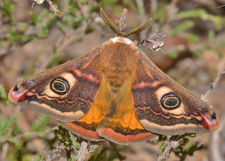
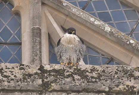
Broxhead Common is a very important site for many species like the Emperor Moth, Tiger Beetle, Adder, Silver-Studded Blue and Clouded Buff Moth


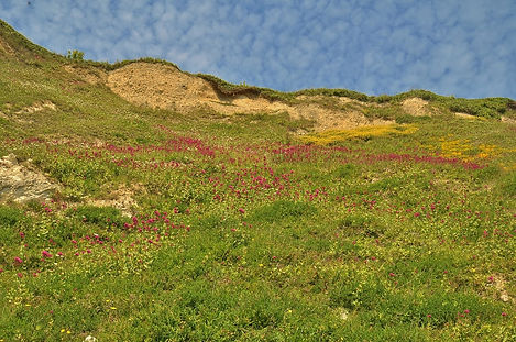
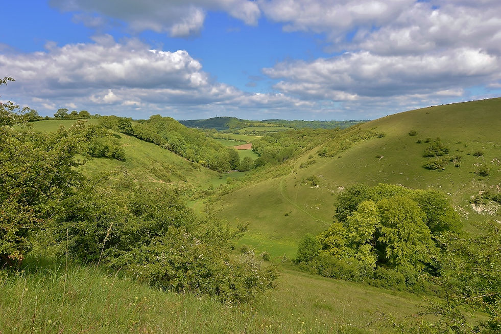
Chalk downland is as important as Tropical Rainforest, in which Hampshire has a good percentage preserved in the south downs national park. This is Park Hill close to East Meon in the Meon Valley
.jpg)
Bell and Ling Heather is a very important plant which is found in the New Forest, on the Army ranges in and around Bordon in eastern central Hampshire and in the borders with Berkshire.
Lowland Heath/Bog
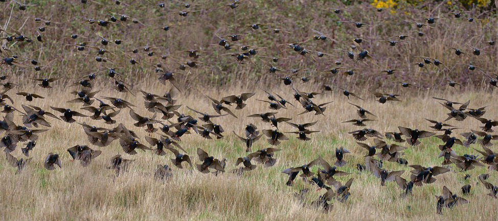
Acid Grassland Lowland heathland is characterised by open expanses of heather, gorse and crossleaved heath on acidic soils, and generally found below 300m. Hampshire’s lowland heaths are of international importance. The county contains 16,000 to 17,000 ha - about 13% of the heathland left in Europe and 30% of the UK total. Much of the heathland is located in the New Forest, with the rest scattered across the Thames Basin, Western Weald, and a few fragments in south Hampshire. Hampshire’s heathlands are particularly important for birds, insects and spiders. They are also vital habitats for reptiles and amphibians: all 12 British species - including sand lizard, smooth snake and natterjack toad - are found here. One of the greatest threats facing heathland is lack of management. Fragmentation and disturbance from development also threaten these very valuable areas.


Lowland Pasture Woodland/Parkland

Pasture woodlands are landscapes composed of a mosaic of extensively grazed, or once grazed, wooded and open habitat. Hampshire is of national importance for this habitat because of the large amount of pasture woodland located in the New Forest. Medieval deer parks also contain important vestiges of wood pasture in more open communities of pasture and ancient pollard trees. Although there is some 600 ha of relic pasture woodland and parkland recorded in Hampshire, the total amount in the county is unknown as it often occurs as unmanaged ancient woodland, wooded common, or as scattered trees in farmland. Pasture woodlands such as those in the New Forest contain very old trees with tree-hole nesting birds and bats, lichens, fungi and deadwood invertebrates. This rich assemblage of species can be of international importance and is one of the reasons for recommending the New Forest as a Special Area of Conservation. Major threats to this habitat are cessation of grazing and removal of dead wood and old trees. In many areas there is also a large ‘generation gap’ between the very old and young trees which leads to loss of habitat continuity, usually caused by overgrazing in the past.


_JPG.jpg)
_JPG.jpg)
.jpg)
.jpg)
Calcareous Grassland
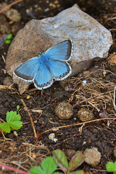
Calcareous grassland is species-rich and occurs on chalk or limestone. This habitat in Hampshire is very fragmented and mostly confined to the steep slopes of the central downs and the chalk escarpment in the north. Less than 2,800 ha - 5% of the UK resource - now remains. Nationally, an overwhelming 95% of this rich habitat has been lost during the past 50 years. These grasslands contain an exceptional diversity of plant species, many now scarce in Britain. Many butterflies such as the adonis blue, duke of Burgundy and chalk hill blue are also in serious decline due to the small, fragmented nature of the remaining areas of chalk grassland. Major threats to this habitat include lack of management, overgrazing, and agricultural improvements through application of fertilisers and herbicides.
.jpg)
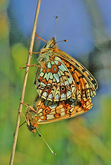
Mottistone Down on the Isle of Wight has a rich diverse flora and fauna including a well established colony of the Glanville Fritillary, Photo Nikki Kownacki
Unimproved Neutral Grassland/Fen
Unimproved neutral grasslands vary in their pH and wetness and include marshy ‘fen’ meadows associated with river floodplains, peaty ‘fen’ meadows associated with springs and flushes, wet and dry loamy/sandy meadows, and clay meadows. Surveys in the 1980s show about 3,000 ha of these meadows in Hampshire. The total UK resource is now thought to be less than 15,000 ha. In Hampshire many of these areas comprise a mixture of wet and dry grassland. They are often associated with the flushes, streams and ditches of water meadows and many are SSSIs. Most are managed as grazed pasture, with few still managed as traditional hay meadows. Herb-rich meadows are particularly important due to a high proportion of herbaceous plants, including many now regarded as nationally uncommon: greenwinged orchid, marsh helleborine and flatsedge. Across the UK, 97% of this habitat has been lost between 1930 and 1984, making it one of the most endangered in Britain today. Calcareous Grassland Calcareous grassland is species-rich and occurs on chalk or limestone. This habitat in Hampshire is very fragmented and mostly confined to the steep slopes of the central downs and the chalk escarpment in the north. Less than 2,800 ha - 5% of the UK resource - now remains. Nationally, an overwhelming 95% of this rich habitat has been lost during the past 50 years. These grasslands contain an exceptional diversity of plant species, many now scarce in Britain.
Many butterflies such as the adonis blue, duke of Burgundy and chalk hill blue are also in serious decline due to the small, fragmented nature of the remaining areas of chalk grassland. Major threats to this habitat include lack of management, overgrazing, and agricultural improvements through application of fertilisers and herbicides. Floodplain Grazing Marsh Floodplain grazing marsh is grassland which is periodically inundated. The grassland itself is generally improved, but ditches can be rich in plants and invertebrates. Most sites are grazed, although some are cut for hay or silage. Species-rich fen meadows found in the floodplain are included in the unimproved neutral grassland/fen habitat type above. Grazing marsh is very important for breeding waders such as snipe, lapwing and curlew, and internationally important for populations of wintering wildfowl such as Bewick and Whooper swans.
The Biodiversity of Hampshire and the Isle of Wight
Hampshire is exceptionally rich in wildlife and diverse landscapes. But many habitats have been lost or damaged, and there is a pressing need to conserve and enhance those which remain. The audit has enabled the identification of habitats and species of priority concern.
Hampshire is one of the richest areas for wildlife in England. The county contains a landscape of remarkable contrasts and a diversity of habitats unparalleled in other parts of south-east England. Although Hampshire is largely a rural county, there are also large urban areas. The Biodiversity Action Plan aims to conserve all aspects of the county’s biodiversity: it is just as critical to keep the commonplace common, as keeping the rare from extinction. An audit is an essential first step to identifying the quality and range of habitats and species in the county. This has been carried out by the Partnership and has enabled the identification of habitats and species of national concern and Hampshire concern requiring priority attention. The audit has identified the extent, quality and distribution of wildlife habitats as well as past trends and losses.
Habitats
Diversity and Importance Hampshire’s mosaic of habitats includes ancient woods, wildflower meadows, heathlands, chalk downland, river valleys, coastal habitats, and the New Forest - the greatest area of ‘semi-wilderness’ left in lowland England. Together these habitats support an exceptionally varied flora and fauna. Sites of Special Scientific Interest (SSSIs) are designated to protect examples of Britain’s most valuable wildlife habitats. In Hampshire, SSSIs cover 48,000 ha - some 13% of the land area. This is about twice the national average of 6.8%. Many of the SSSIs have been recognised for their international importance too: 41,700 ha (about 11 % of Hampshire) have been designated (or are proposed) as Special Areas of Conservation (SACs) or Special Protection Areas (SPAs) under EC Directives, and/or as Ramsar Sites under the Convention on Wetlands of International Importance. But this is only part of the picture. Statutorily designated sites protect only some of the best examples of Hampshire’s habitats. Sites of Importance for Nature Conservation (SINCs) are also being identified within Hampshire, jointly by Hampshire County Council, district councils, English Nature and Hampshire Wildlife Trust. The purpose of these is to help conserve, and direct resources to, additional areas of important wildlife habitat. This network of locally designated sites currently covers a further 6% of Hampshire. Even outside the specially recognised sites, the rest of the county is exceptionally rich. Scrub, field margins, hedgerows, ponds, mature trees and urban greenspaces all contribute to Hampshire’s biodiversity and are of particular value to people in their everyday lives.
Losses and Threats
Despite the richness and extent of valuable habitat in Hampshire, the county has suffered immense losses during the past 200 years. Some habitats have declined drastically in extent and have become very fragmented. Many areas have been lost to built development - houses, industry, roads and marinas - or become degraded through changes in agricultural practice and afforestation. For example: • 50% of ancient semi-natural woodland has been lost in the past 50 years • over 90% of heathland has been lost in north-east Hampshire in the past 200 years • 98% of chalk downland has been lost in the past 150 years These statistics highlight the pressing need to conserve those areas that remain and enhance or restore other areas of valuable wildlife habitat. Built development results both in outright loss and in degradation due to secondary impacts such as increased water abstraction, loss of buffer zones and increased pressure from people. Changes in agricultural practice have caused the loss or impoverishment of wildlife habitats through alteration of drainage patterns, spraying with pesticides and herbicides, nutrient enrichment, or removal of farm features such as hedges.
For each key habitat, a UK action plan has been, or will be, prepared under the UK Biodiversity Programme. From the list of 38 key habitats of conservation concern in the UK, 18 occur in Hampshire. An additional 3 habitats have been identified by the Hampshire Biodiversity Partnership as being of local concern within the county: road verges, canals, and urban habitats. For each of these priority habitats a detailed action plan will be prepared and included in Volume 2 of the Biodiversity Action Plan. The purpose of the 21 habitat action plans is to both reflect UK objectives and targets for habitats of particular conservation concern, and to set appropriate local targets. Action plans will fully review the status and current action for key habitats, and set detailed objectives and targets, identifying particular areas for urgent action. These changes were largely supported and encouraged by successive governments striving to ensure that Britain become more self-sufficient in food production. Afforestation has also resulted in loss or degradation of habitats, particularly heathland and ancient woodland. The dramatic rate of loss in the past has declined and land-use practices such as agriculture and forestry are now much more sensitive to nature conservation. However, significant pressures remain: for example space must be found for a considerable number of new homes between 2001 and 2011. Many valuable sites are also suffering from lack of appropriate management.
An Audit of Hampshire’s Habitats
At the UK level, the whole land surface and surrounding sea has been divided into 37 broad habitat types. Hampshire contains 23 of the UK’s 37 broad habitat types, and together these cover the entire land area within the county. At the UK level, key habitats have also been identified and these are habitats of particular national concern. Some key habitats match the broad habitat type - for example ‘calcareous grassland’ is both a broad and key habitat - whereas others are subdivisions of broad habitat types - ‘arable farmland’ is a broad habitat type and ‘arable field margins’ is the corresponding key habitat. Within the 37 broad habitat types found in the UK, 38 key habitats of particular UK conservation concern have been identified. Key habitats were selected using one or more of the following criteria: • habitats for which the UK has international obligations • habitats at risk, such as those which are rare or have a high rate of recent decline • habitats which are functionally important for species inhabiting wider environments, for example spawning grounds for fish • habitats important for species of particular conservation concern Marine Habitats The national biodiversity programme is reviewing marine broad habitat types and the selection of key marine habitats. The Hampshire Biodiversity Programme will incorporate marine habitats and the preparation of relevant action plans when the national review has been completed. BROAD AND KEY HABITATS UK HAMPSHIRE 37 broad habitat 23 broad habitat types types found in UK present in Hampshire
Broad Habitat types found in Hampshire
The following summaries of the 23 broad habitat types define what the habitat is, its extent in Hampshire and its relative importance in the UK. Main factors affecting the status of each habitat are also given. Fuller details of distribution and extent, factors affecting the habitat, and the broad conservation direction required will be given in Volume 2. Broadleaved/Yew Woodland/Scrub Hampshire contains approximately 42,000 ha of broadleaved woodland - about 11% of the county - and a further 3,000 ha of scrub. About half of this woodland is ancient and has been in existence since the Middle Ages. Ancient semi-natural woodlands - those with stands of native trees not obviously planted - are particularly rich and diverse in wild plants and animals. A characteristic feature of many of these woods is spring carpets of bluebells - a feature which is quite particular to Britain. Although Hampshire is of national importance for this habitat, holding about 5% of the UK resource of ancient semi natural woodland, 50% has been lost to agriculture, mineral extraction, urbanisation and plantations in the past 50 years.
Today the major threat is lack of traditional management practices such as coppicing. Coniferous Woodland Coniferous woodland accounts for about 20,000 ha or 30% of Hampshire’s woodland resource. Almost half of this type of woodland occurs within ancient woodlands. Other major complexes include large plantations over former heathland. Conifer plantations on chalk are generally biologically impoverished, although the rides, glades and woodland edges often support an interesting downland flora and fauna. Plantations over heathland, however, can retain valuable relic heathland communities, although this is generally more by luck than design. Some of these areas are of international importance for their populations of bird species such as nightjar and woodlark.
Hedgerows
Hedgerows are linear features composed of woody species, sometimes raised on grassy banks. Hampshire retains a traditional patchwork of small fields, woods and hedgerows, particularly in the north and south of the county. Winding parish boundaries and ancient lanes are often defined by hedgerows, many in existence since medieval times. Hedgerows are very important ecologically, resembling woodland edge and scrub habitats. Ancient hedgerows possess a particularly rich variety of trees, shrubs and ground flora, and in some landscapes, hedgerows are one of the few refuges left for wildlife. Factors affecting this habitat include destruction, lack of management and mismanagement. Continued agricultural intensification to create bigger fields, urban expansion, new roads and other development all contribute to hedgerow destruction, although in recent years net loss has slowed considerably. Lack of management leads to overgrown, gappy hedgerows which are less valuable to wildlife. Some hedges are poorly managed and cut at the wrong time of the year, cut too short, or cut too frequently. All of these factors reduce the value of hedgerows for biodiversity. Arable Farmland Arable land is either that which is under cultivation, or temporary grassland of less than five years. Approximately 37% or 141,000 ha of farmland in Hampshire is arable: just below the national average of 41%. The county provides about 3% of the total UK resource. It is Hampshire’s largest single type of land-use.
Despite the effects of agricultural intensification, Hampshire still possesses what is probably the richest and most diverse arable weed flora of any county in Britain. Nevertheless, much of the wildlife interest is confined to field margins where herbicides and competition from the crop can be avoided. A large number of insects spend part of their life cycle in cereal fields and they are a source of food for many birds and mammals including grey partridge, skylark, lapwing and corn bunting. The use of herbicides and insecticides has led to a decline in many of these species. Improved Grassland Improved grassland is intensively managed, species-poor, and dominated by a few species of grass. There are about 66,000 ha of this habitat in Hampshire, 90% of the county’s grassland. This represents 31% of all farmland or 17% of the county land area. Improved grassland is sown for agriculture or amenity, or created by modification of unimproved grassland by fertilisers and selective herbicides. Biodiversity is low. Few plants other than competitive grasses survive, and there is also a very impoverished fauna. The change over the past two decades from hay to silage has further degraded this habitat. These grasslands may support a range of ground nesting birds such as lapwing and skylark if machinery is used infrequently and stocking densities are low.
Floodplain Grazing Marsh Floodplain grazing
marsh is grassland which is periodically inundated. The grassland itself is generally improved, but ditches can be rich in plants and invertebrates. Most sites are grazed, although some are cut for hay or silage. Species-rich fen meadows found in the floodplain are included in the unimproved neutral grassland/fen habitat type above. Grazing marsh is very important for breeding waders such as snipe, lapwing and curlew, and internationally important for populations of wintering wildfowl such as Bewick’s and whooper swans. The main threats to this habitat include agricultural intensification and associated drainage, inappropriate ditch management, ground water abstraction, encroaching development and climate change which is causing increased evaporation and lower rainfall.
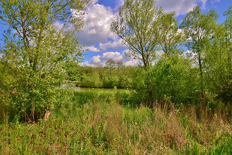
Fen/Carr/Marsh/Swamp/Reedbeds
Fen, carr, marsh, swamp and reedbeds often occur together and are scattered throughout Hampshire principally along the river valleys and coast. Species-rich fen tends to be inextricably associated with ‘fen-meadows’ and dry unimproved grassland, and so is largely included in the broad habitat ‘unimproved neutral grassland/fen’. Species-poor fen is often associated with reedbeds and swamp vegetation found along watercourses and around pools of water. It commonly grades into fen-carr dominated by alder and willow
A mixture of open fen and carr can support an exceptional range of plants, insects and birds, and at one time the river valleys must have been a continuous mosaic of these habitats.Today they tend to be isolated, separated by improved pasture and arable land. The amount of this resource in Hampshire has been conservatively estimated at 400 ha. Fens are dynamic ecosystems and require management to maintain their open character; otherwise they develop naturally to scrub and woodland. Generally, the factors affecting these habitats include lack of, or inappropriate, management, and fragmentation and loss caused by water abstraction, drainage, encroaching development, and climate change. Future sea level rise may lead to loss of reed beds along the coast through coastal ‘squeeze’. Standing Open Water Hampshire has a large number of lakes, ponds and gravel pits - as many as 500 lakes (> 0.5 ha) and over 1000 ponds (< 0.5 ha) scattered across the landscape. This resource has declined nationally by an estimated 75% over the past 100 years.
Virtually all of Hampshire’s lakes are man made and have been created to provide a head of water for mills, fish for a nearby settlement, or as part of the landscape setting of country houses. More recently, lakes have been created in the river valleys of the Avon, Test and Blackwater as a result of gravel extraction. Many are important for overwintering and breeding birds. The majority of ponds are also man-made. Originally they were created to provide water for a village or for farm livestock, as decoys for wildlife, or as a result of abandoned clay pits. Today they tend to be created for fishing purposes. Only a few ponds result from a naturally high water table, but these tend to disappear during hot, dry summers. Nevertheless, they provide ideal conditions for some rare invertebrate species such as the fairy shrimp. Neglect, infilling and eutrophication from fertiliser run-off are major causes of decline in standing open water. Rivers and Streams Hampshire has some of the finest chalk rivers in Britain: the Test, Avon, Itchen and Meon, and a number of other rivers such as the Lymington, Beaulieu, Loddon, Whitewater,Wey, Rother and Blackwater. Chalk rivers are particularly important for their assemblages of plant species: the clarity of the water provides the light needed to stimulate luxuriant growth. Beds of river water crowfoot, lesser water parsnip and water starwort are host to a variety of invertebrates such as flatworms, snails, water bugs and beetles and are of national and international importance.
The Chalk Rivers of Hampshire are also important for fish: notable species include brown trout, salmon, bullhead, brook lamprey and sea lamprey. The Avon,Test and Itchen are all notified as SSSIs, and the Avon and Itchen are also candidate Special Areas of Conservation (cSACs) for their floating vegetation of water crowfoot. The Avon is also a candidate SAC because of its fish populations. Other rivers are important for other groups of animals and plants according to their nutrient status. For example, the more acid rivers of the New Forest and the River Enbourne along the northern county boundary support a much richer dragonfly fauna than the chalk streams. In addition to the Chalk Rivers mentioned above, the Lymington is also an SSSI. Current factors affecting rivers and streams in Hampshire include: ground and surface water abstraction; pollution from sewage, fish farms and fertiliser and soil run-off; inappropriate bank management and engineering works; and climate change.
Rivers and Streams
Hampshire has some of the finest chalk rivers in Britain: the Test, Avon, Itchen and Meon, and a number of other rivers such as the Lymington, Beaulieu, Loddon, Whitewater,Wey, Rother and Blackwater. Chalk rivers are particularly important for their assemblages of plant species: the clarity of the water provides the light needed to stimulate luxuriant growth. Beds of river water crowfoot, lesser water parsnip and water starwort are host to a variety of invertebrates such as flatworms, snails, water bugs and beetles and are of national and international importance. The chalk rivers of Hampshire are also important for fish: notable species include brown trout, salmon, bullhead, brook lamprey and sea lamprey. The Avon,Test and Itchen are all notified as SSSIs, and the Avon and Itchen are also candidate Special Areas of Conservation (cSACs) for their floating vegetation of water crowfoot. The Avon is also a candidate SAC because of its fish populations. Other rivers are important for other groups of animals and plants according to their nutrient status. For example, the more acid rivers of the New Forest and the River Enbourne along the northern county boundary support a much richer dragonfly fauna than the chalk streams. In addition to the chalk rivers mentioned above, the Lymington is also an SSSI. Current factors affecting rivers and streams in Hampshire include: ground and surface water abstraction; pollution from sewage, fish farms and fertiliser and soil run-off; inappropriate bank management and engineering works; and climate change. Canals Hampshire once had several canals and river navigations: the Itchen Navigation, the Basingstoke Canal, the Southampton and Salisbury Canal (with a branch to Andover), the Titchfield Canal and the Portsea Island Canal. The Itchen Navigation was not a true canal but a linked series of ‘cuts’. These have been replaced by weirs and the distinctive slow-moving waters typical of canals have been lost.Very little of the Southampton and Salisbury Canal remains except for a small stretch of the Andover section near Romsey
The 4 km Titchfield Canal, constructed in the 1600s between the sealock at Titchfield Haven and the then ‘Port’ of Titchfield, was one of the first recorded canals in England. It became redundant within 100 years, but has recently undergone some restoration work. Part of it lies within the Titchfield Haven National Nature Reserve. The only sizeable canal remaining is the Basingstoke Canal. The 24 km in Hampshire (0.4% of the total UK resource of 6,400 km) has become one of the most important wetland habitats in the UK since it was restored between 1976 and 1991. This is due to the unusual transition from calcareous spring water in the west to more acidic conditions in the east, resulting in an extremely diverse aquatic flora and fauna, including 24 species of dragonfly. Potential threats to canals include increased recreational pressure, decreasing water levels, pollution and the presence of invasive species. Maritime Cliffs In Hampshire, maritime cliffs are soft and erodable and liable to cliff falls and slumping. They are nationally important for plant and animal fossils and for their invertebrate fauna. Open unstabilised areas of cliff are particularly important for invertebrates. The main threat to this habitat is coastal defence works: these isolate the cliff faces from the intertidal zone and encourage growth of stabilised slopes with scrub. Whilst erosion at the foot of the cliff is beneficial to biodiversity, it is not so at the cliff top where valuable maritime vegetation needs to be allowed to retreat landwards. The encroachment of urban development and cultivated land towards the sea squeezes and erodes this valuable resource. Shingle Much of the coastline of Hampshire is covered by shingle beaches. This is sometimes mixed with sand or silt, and forms transitions to other habitats such as saltmarsh and grassland. Many shingle spits or beaches are mobile and therefore unvegetated: vegetation will only establish where there is a matrix of finer material such as sand or silt, and the structure is stable. Vegetated shingle is a nationally rare habitat. Pioneer species on undisturbed shingle in Hampshire include sea kale, the yellow horned poppy and ‘little robin’ - a nationally rare plant. Important fauna on shingle include breeding colonies of terns and a number of nationally rare invertebrates. Shingle is mostly threatened by recreational pressure and sea defence works. Saltmarsh The Hampshire coast supports extensive areas of saltmarsh: 2,660 ha or 6% of the UK total. Saltmarsh develops along sheltered coasts and estuaries and represents a transition from mudflats which are completely inundated by tides, to upper saltmarsh which is infrequently inundated. Saltmarsh often grades into freshwater marsh, shingle, heath, scrub and oak woodland. These transitional habitats are particularly valuable for invertebrates. Over half of the saltmarsh in Hampshire is dominated by the hybrid cord-grass Spartina anglica. The cord-grass marshes of the Solent are of international importance as the original site for the introduction and development of this hybrid species now found worldwide. Other saltmarshes in the region are more typical mixed communities which support species such as glasswort, sea aster, sea purslane and a variety of saltmarsh grasses. Nationally important colonies of black-headed gulls and breeding terns are found on areas of saltmarsh, and the majority are notified as SSSIs. The main threats to saltmarsh include land reclamation for urban, port, transport and industrial infrastructure, coastal defence works, waste disposal and recreational pressures. The biggest threat in future is likely to be sea level rise and consequent coastal squeeze.

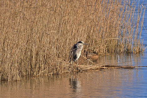
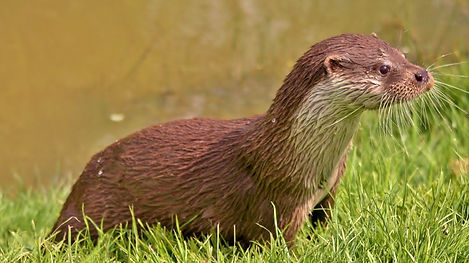
Chalk streams are a very important indicator of how well flora and fauna are doing, especially rare animals like Otters, Water Voles and Kingfishers.

Water Voles have been re-introduced in the River Meon at Soberton in the chalk-stream, where they have been doing rather well and have successfully bred
.jpg)

Kingfishers have become commoner over the last few years, especially in and around Winchester at Winnel Moors and along the Basingstoke Canal.

.jpg)


.jpg)